Bushy Lake Geology and Soils

Bushy Lake Geology and Soils
Before European settlement in 1849, the floodplain along the American River consisted of continuous, extensive riparian forests and vegetation. The riverine fluvial geomorphology and soils characteristics were transformed by European human settlement, upstream dam and levee construction, and gold and gravel mining. When the lower American River levees were built, topsoil from the Bushy Lake area was used to construct the levees. The Bushy Lake site was graded to become a golf course in the mid-1900’s, and soils have been compacted, resulting in a highly modified soil profile.
Pictured at left: Dr. Andrew Margenot and students digging soil pit at Bushy Lake for analysis of sequestered carbon in the soils.
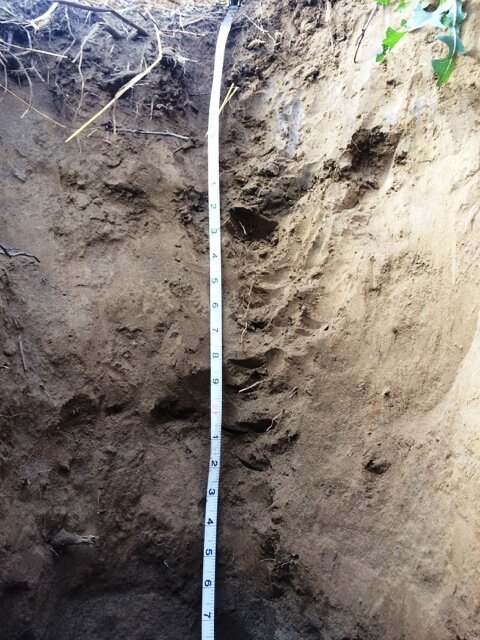
Soils of Bushy Lake are formed by a combination of human compaction and alluvial deposition. Soils are mapped as the Rossmoor fine sandy loam (Fluventic Haploxeroll) and Columbia sandy loam (Aquic Xerofluvent) (NRCS Soil Web Survey). Both soils share similar physical and chemical properties. The Rossmoor and Columbia series formed from alluvial depositions on floodplains with low (0-2%) slope. They are distinguished by a mollic epipedon in the Rossmoor series indicative of higher soil organic C in the surface (0-6 in) horizon and reflective of this series position on higher floodplains, whereas the Columbia is typically located on lower floodplains lacks stratification including this organic-rich surface horizon. However, the high degree of human activity and landscaping at this site, including leveled terraces for a golf course, suggests homogenization of these differences in surface horizons, further increasing similarity of soil properties at the site. Additionally, past and recent fires have modified C concentrations in the surface horizons, further altering taxonomic classification.
A soil analysis was done at the Bushy Lake area in 2014 by Dr. Andrew Margenot, who analyzed soils sampled from two soil pits. The observations showed that the top 6 in of the soil upper horizon contains soil organic matter (SOM) darkening, consistent with the mollic epipedon mapped in the Rossmoor series.
The soils at Bushy Lake have a limited ability to sequester carbon. Soil C stocks to a depth of 25 in were estimated to range from approximately 38-60 t ha-1 with a mean of 50.9 t ha-1. Restoring vegetation and mulch to disturbed soils at Bushy Lake is a management option that increases surface soil C and is therefore a potential strategy to increase net C storage in soils. Restoration of grasslands has been found to increase C storage at rates of 0.3-6 t ha-1 yr-1. Studies indicate that restoration of soils and native vegetation promotes resiliency to disturbance and increased the potential to out-compete invasive plant species.
Pictured at right: Soil profile of disturbed Rossmoor Soils (#247 on NRCS soils map, below)

Pictured Above: Soil Survey Map of Bushy Lake produced by NRCS. 247 – Rossmoor, 118 – Columbia (NRCS Soil Web Survey, https://websoilsurvey.sc.egov.usda.gov).